


Ha Giang is not a polished destination. It is not designed for quick check-ins or luxury shopping streets. Ha Giang tours are for travelers who want to see Vietnam at its most rugged, most honest, and most breathtaking. Located in the far north along the Chinese border, Ha Giang Province is known for dramatic limestone peaks, deep river canyons, ethnic minority cultures, and the legendary Ha Giang Loop.
If you are wondering whether Ha Giang is worth your time, how many days you need, and what you will truly experience on the road. This guide explains everything clearly and practically for planning your trip in this year.
The best time to visit Ha Giang is from September to November and from March to May. Autumn (September to November) is when the rice terraces turn golden and the weather is cool, dry, and clear, perfect for long scenic drives and photography. Spring (March to May) brings blooming flowers, fresh greenery, and comfortable temperatures for trekking and village visits.
Winter (December to February) can be surprisingly cold, especially in Dong Van and Meo Vac where temperatures sometimes approach 0°C at night. The rainy season (June to August) makes the mountains extremely lush, but roads can be slippery and visibility may drop in heavy fog or rain.
>>> If you want stable weather and open views across the valleys, plan your Ha Giang tour in autumn or spring.
The must-see places in Ha Giang are Ma Pi Leng Pass, Dong Van Karst Plateau, Nho Que River, Lung Cu Flag Tower, and the ethnic villages along the Ha Giang Loop. Most travelers explore these highlights through a 3-5 day Ha Giang Loop tour, either by private car or with a professional motorbike driver.
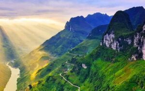
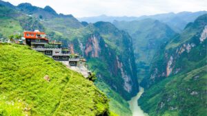
Ma Pi Leng Pass is the most dramatic road in Vietnam. This mountain pass between Dong Van and Meo Vac cuts along sheer limestone cliffs hundreds of meters above the Nho Que River. The views are wide, deep, and raw, there are no safety nets or glass walkways here, just real mountain terrain. It is the section of the Ha Giang Loop that travelers remember most.
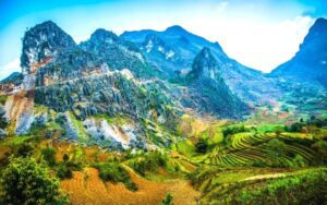
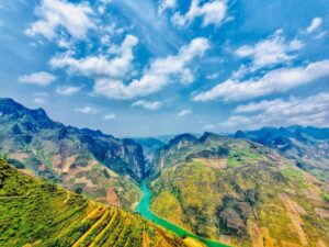
Dong Van Karst Plateau is a UNESCO Global Geopark formed over 400 million years ago. The landscape is not soft or green like Sapa. Instead, it is rocky, ancient, and powerful. Limestone mountains rise sharply from narrow valleys where ethnic communities farm corn and buckwheat on stone terraces. Dong Van town itself has a small old quarter with traditional clay houses and weekend ethnic markets.
Nho Que River is the emerald ribbon running through Tu San Canyon. From above, it looks unreal, a bright green river slicing through towering cliffs. Boat rides allow you to see the canyon from below, where the scale of the landscape feels even more overwhelming. This is one of the most photogenic natural sites in northern Vietnam.
Lung Cu Flag Tower marks the northernmost point of Vietnam. Standing at the top of Dragon Mountain, the red Vietnamese flag flies close to the Chinese border. The climb is short but steep, and the view stretches across valleys dotted with ethnic villages. For many travelers, this stop feels symbolic, you are literally standing at the edge of the country.
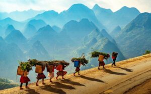
Meo Vac is known for its Sunday ethnic market. Every Sunday, Hmong, Tay, and Dao people gather in traditional clothing to trade livestock, food, and handmade goods. It is not staged for tourists, it is a real weekly social event.
The thirteenth day is where this two-country trip earns its depth. A Vietnam and Cambodia in 13 Days itinerary keeps the classic…
The famous pagodas and temples in Vietnam map the country’s soul as accurately as any history book: a 1,500-year-old pagoda on a…

Vietnam stretches over 1,650 km from north to south, and the weather in Hanoi can be the complete opposite of what is…